
Is in south Omo zone, 35km south west of Jinka, the administrative center of the zone. The Mago Rivers flows through the centre of the park and joins the Neri Rivers of Mago swamp, before continuing south wards as the Usno to join the Omo River. The River wich is 760km long, originates in the central, south – western highlands of Ethiopia, where it is known as the Gibe. Its final destination is Lake Turkana, close to the Kenya border.
Mago national park proclaimed in the 1960, the 2162km square is bisected by the Mago Rivers wich flows in to the Omo in the parks southern boundary. Although Mago national park share some 5km of its south western boundary with Omo national park, the protected areas effectively form one ecological unit.
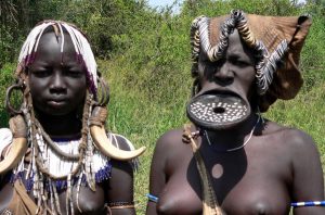
The altitude at the edge of the park is 400m. To the east are the Mursi Hills, rising to over 1600m, North of the Neri Rivers are the Mago Mountain with the highest point, Mount Mago at 2528m. The southeastern quarter of the park is closed by many small streams and Rivers. The headquarters for the park are by the Neri River, near the entrance from Jinka. The main habitats of the park and surrounding area are the river and riverine forest, the wetlands of Mago swamp and lake pipa, the bush land and scrub on the sides of the hills. Open grasslands comprises just 9% of the area, the rest of the area being described as very dense. The largest trees are found in the Riverine forest beside the Omo, Mago and Neri. Areas along the lower Omo (within the park) are populated with a rich diversity of Ethnic groups including the Ari, Banna, Bongoso, Hamer, Karo, Kwegu, male and Mursi peoples. A number of these groups live beside the River and make extensive use of its natural resources and its levees to grow crops.